1750 Sugar House, for grinding cane, near western end of modern Mount Gould Rd, its ruins long thought to have been an old fort. (Gill)

1750 Sugar House, for grinding cane, near western end of modern Mount Gould Rd, its ruins long thought to have been an old fort. (Gill)
1830s BRYANT & JAMES (Mill Lane)
1838-56 BRYANT & BURNELL (Mill Lane)
1851 BENSON Gerd & John (Mill St Sugar House)
1851 BRYANT James, jun. (Mill St Sugar House)
1890 BATES, Sir Edward
For further details of the Mill Lane site, click here.
1663/4-1712 BUTTALL Samuel
1712-23 BUTTALL Samuel & BUTTALL Humphrey
1723> BUTTALL Humphrey
PLYMOUTHCLICK the (For local directory of sugar houses, click here.) (For national directory of sugar houses, click here.) |
 |
|
The length of this map represents 2.8ml / 4.5km. |
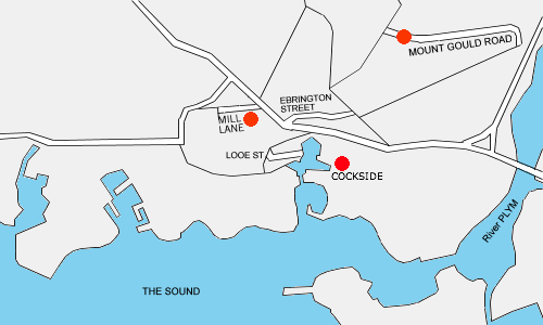
The refinery site in Mill Lane would have stood very central in old Plymouth .... a site
which some 250 years earlier had provided the garden for the house, in Saltash St, of Sir
Francis Drake, sometime later the Frankfort Barracks, and just prior to the refinery, a
tannery and vegetable garden. The Waste (Mill) Leat, capable of turning a mill wheel, provided
the water supply and power throughout these years.
In the 1830s, James Bryant, who had already opened a starch factory on part of the site,
revived the sugar refining industry which had declined at the end of the previous century.
One of the first works had been on the eastern side of Sutton Pool, and there was a round
"cane grinding" building in Exeter Rd. By 1844 his refinery was insured for Ł5500 by the
Phoenix Fire Office.
Partnership with Mr Burnell soon came, and in 1856
the refinery became the British and Irish Sugar Refining Company, with Bryant and Burnell
appointed deputy chairmen, and with business booming the town had four refineries, with,
at one point, the sugar duties accounting for half the Customs receipts for the Port. But,
in 1886 the company became unprofitable and was sold, and in 1890 was acquired by Sir Edward
Bates MP, though he soon sustained heavy losses, and closed down. From then on the site had various uses - shops, stables, clothing factory, builder's
merchants, cooperage, telegraph stores, and furniture repository, as well as being the winter
store for Hancock's fair and menagerie. ** Here are three images of the old Mill St building when in the ownership of woollen merchants Butt, Vosper & Knight ......
One, Two, Three. ** Before WWII, one of the two 120ft chimneys was carefully demolished, but the Blitz soon claimed
the largest of the buildings on the site. With the 5-storey ones gone, it left the clothing
factory and warehouse - the original 3-storey refinery buildings with limestone walls and
granite corners, rows of little windows with red brick frames, and original hoists still
serving the goods doors. With the centre of Plymouth destroyed by the Blitz, in 1953 the
site was in the way of the "development" of the town's new centre, and has finished up
beneath the multistorey car park in Mayflower Street ! *** The Western Morning News of 13 Oct 1913 ran an advert for "Sugar Beet - The New National
Industry - Cornwall's Opportunity" offering farmers Ł17,500 of free shares in the Cornwall
Sugar Beet Company Limited for the first 3,500 acres contracted for, or five shares per acre,
giving automatic share ownership of the Hayle Beet Sugar Factory [still to be built !]. The
organisers were B. Tunstall Behrens of Porth-en-alls, Marazion and W. J. Hosken of Pulsack, Hayle. ***
Sources - [I wish to thank Peter & Jenny Towey for their help in researching this page.]
The PLYMOUTH REFINERY in Mill Lane

Approximate locations then and now.
Did the venture ever come to fruition ??
* Western Morning News, Thursday, September 18, 1952.
* Ref P664.1, Plymouth Local Studies Library.
* OS maps of Plymouth for 1867 & 1994.
* 1943 Plan for Plymouth.
* Western Morning News, October 13 & 15, 1913.
* 'Plymouth - A New History, 1603 to the Present' by Crispin Gill, Vol 2.