SUGARHOUSE ARCHAEOLOGY


*********


Unusually, this page is "in progress". The index shows what I hope to achieve, but I'll be adding text to the page as I research each dig.
Bold text in the index will link to content for that location. Contributions gratefully accepted.

See the links on the Locations page that may give more details of the working sugarhouse.


*********


Index ...

  BRISTOL - Cherry Lane
  BRISTOL - Tucker St
  BRISTOL - Westbury-on-Trym (a pottery)
  CHESTER - Bridge St
  DUNDEE - Seagate
  EDINBURGH - Canongate
  ESSEX - Stock (a pottery)
  EXETER - Goldsmith St
  (HULL - Lime St)
  GLASGOW - Gallowgate (a pottery)
  LANCASTER - Phoenix St
  LIVERPOOL - Manchester Dock
  LIVERPOOL - Prescot (a pottery)
  LIVERPOOL - South Castle St
  LONDON - Deptford
  LONDON - London Hospital Medical College
  LONDON - Morocco St, Southwark
  LONDON - Mortlake
  LONDON - Old Paradise St, Lambeth
  LONDON - Patience St, Bishopsgate Goods Yard
  LONDON - Prescot Street
  LONDON - St Mary Axe
  LONDON - Swan St, Southwark
  LONDON - Upper Thames St
  LONDON - Whitechapel Road
  LONDON - Woolwich
  PLYMOUTH - Cockside
  SOUTHAMPTON - Gloucester Sq
  YORK - Skeldergate

  MONTSERRAT, WI - Galways

Wherever there was sugar refining you'd hope to find some evidence.
Rarely a sugarhouse, more likely some pottery but often where least expected.


*********


*****

BRISTOL - Cherry Lane

Data ...
        Location : Cherry Lane, Stokes Croft, Bristol
        Grid : ST 58987367
        Sugarhouse : No
        Pottery : Yes
        Year of dig : 2003
        Sources : Transactions of the Bristol & Gloucestershire Archaeological Soc, Archaeological Review No.28, J Wills (ed), 2004 vol 122

Summary ...
              "An archaeological watching brief during ground-works associated with the construction of a new apartment block recorded standing 18th-century remains including a stone-built well and the remains of 18th-century cellars. The only significant finds recovered were several large sherds of red earthenware sugar moulds dating from the early 18th century. - Tim Longman, BaRAS."
No sign of a sugarhouse here, with the nearest being Montague St and Wilder St. Neither of these would have been early enough, so Whitson Court (1665-1824) most relevant ... though these few moulds could have been from any one of a dozen refineries working 1700-1725.


*****

BRISTOL - Tucker St

Data ...
        Location : Tucker St, Bristol
        Grid :
        Sugarhouse : No
        Pottery : No
        Year of dig : 2000-1
        Sources : Archaeological Excavations at the Former Courage Brewery, Bath St, Bristol 2000-2001 by Reg Jackson ... Bristol & Avon Archaeology Vol 21 2006.

Summary ...
              In Tucker Street there have been sugarhouses at Nos. 6 and 15, and behind No. 16, however extensive digs in the area have found no evidence.


*****

BRISTOL - Westbury-on-Trym (a pottery)

Data ...
        Location : Trym Lodge, Westbury-on-Trym, Bristol
        Grid : ST57307750
        Sugarhouse : No
        A Pottery : No
        Pottery : Yes
        Year of dig : 2001
        Sources : Pottery Production in Westbury-on-Trym during the late 17th and 18th Centuries, by Reg Jackson, BGAS Transactions Vol. 123, 2005
                      british and irish archaeological bibliography
                      Cardiff Archaeological Consultants - Mike Ponsford

Summary ...
              There appears to have been a pottery, or potteries, in Westbury-on-Trym since the 17th century, with the first documentary evidence for 1691. Various potters, and their employees are recorded in the village records. In 1742, the Burfield or Sugar House pottery was established in the south of the village (ST 57117632) run in succession by the Sanders, Hart, Fricker and Yabbicom families, and producing sugar moulds and jars, chimney pots, flower pots, etc, from locally dug clay. Yabbicoms & Son ceased production in the mid-1790s and took over an established pottery in Bristol. The primary market throughout would have been the numerous sugarhouses in Bristol.
"The evaluation trench at Trym Lodge where masses of waste pottery was found. This had come from a local pottery, probably Messrs Yabbicom who specialised in making sugar loaf moulds and syrup-collecting jars, large garden planters and tall chimney pots." - CAC.
"In Westbury-on-Trym, Bristol, a recent evaluation for Rombourne Ltd found masses of pottery waste from the making of sugar-loaf moulds and syrup-collecting jars used in BristolÕs well-known sugar houses." - Mike Ponsford.


*****

CHESTER - Bridge Street

Data ...
        Location : 25 Bridge Street, Chester
        Grid :
        Sugarhouse : No
        Pottery : Yes
        Year of dig : 2001
        Sources : Excavations at Chester - 25 Bridge Street 2001, Two Thousand Years of Urban Life in Micrcosm, Dan Garner and others, Chester City Council, 2008

Summary ...
              "A total of 153 fragments of sugar cone moulds were found in the post-medieval phases of the site." ... the majority coming from the fill of a cess pit dated 1702 or later. "Whilst not a large dump, the group appears to form the largest assemblage from the city to date. These are of significance in themselves ..."
"The fabrics fall into three fabric groups. None of these have been described from Chester before."
Most of the fragments were body sherds, with just a few fragments of rims and pierced bases. With a variety of fabrics and wide variety of sherds, no complete mould could be assembled.
Significantly, there were no sherds from collecting jars, which points to the moulds being dumped at the location rather than as a result of refining there.
The report suggests the moulds were from Henthorne's White Friars sugarhouse. [The report includes considerable Chester refining history, p.220-222]


*****

DUNDEE - Seagate

Image (on p.3)

Data ...
        Location : South side of Seagate, Dundee
        Grid :
        Sugarhouse : No
        Pottery : Yes
        Year of dig : 2011
        Sources : Medieval Pottery Research Group, Newsletter 71, November 2011
                      Deposits under Dundee's New Leisure Pool, Alder Archaeology Ltd., 2012
                      'The Dundee Sugar House, Seagate, Dundee' by David Perry, et al, 2013-14. See # below.

Summary ...
              "Recent excavation and monitoring of the construction of a new swimming pool and leisure centre on the South side of the Seagate in Dundee located a small assemblage of pottery which included a group of industrial redwares. Some of these pieces were internally slipped white and sherds from syrup jars and sugar cones were present. Initial research on the assemblage by the author has discovered that there was a sugar house operating nearby from 1770-1826 that was set up originally by a German William Wiedemann who was the grandfather of the English poet Robert Browning. Recommendations have been made for the chemical sourcing of a statistical sample of these redwares to identify their provenance." - Derek Hall, 2011.
"The excavation focused on an area to the SE of the site where large warehouse walls had been discovered which were thought to run on the same alignment as the former harbour wall. ... Deposits under West Whale Lane and the warehouse were essentially 19th century dumps of rubble, animal bone, cobbles and ceramic from the former sugar industry." - Alder, 2012.
"The industrial redwares are of 18th/19th-century date and appear to have been dumped from a sugar house in the near vicinity. There is a sugar house on record from 1767 to 1841 in Sugarhouse Wynd which lies some 160m to the NW of the site and these sherds may have been dumped from that operation." - David Perry, et al. 2013-14.

# Full report and analysis now published as 'The Dundee Sugar House, Seagate, Dundee' by David Perry with contributions by Derek Hall and Richard Jones, in Tayside and Fife Archaeological Journal, vol 19-20 (2013-2014), pp103-18.
The records and reports of the various pieces of fieldwork were archived in August 2015 to the Royal Commission on the Ancient and Historical Monuments of Scotland, Bernard Street, Edinburgh (now merged with Historic Scotland as Historic Environment Scotland).


*****

EDINBURGH - Canongate

Data ...
        Location : Sugarhouse Close, 160 Canongate, Edinburgh.
        Grid : NT 26453 73699
        Sugarhouse : Yes
        Pottery : Yes
        Year of dig : 2010-12
        Sources : Headland Archaeology (UK) Ltd - Sugarhouse Close, 160 Canongate, Edinburgh - Archaeological Works for Watkin Jones Group, by Don Wilson. 2012.

Summary ...
              A programme of archaeological works has been undertaken by Headland Archaeology (UK) Ltd to provide a historical record of the site prior to and during its redevelopment for student residences.
There was a sugarhouse on the northern end of this narrow site between Canongate and Holyrood Road from 1752 until the site was cleared and the brewery built in 1868. The exact location of the sugarhouse is shown on the Armstrong map of 1773 through to the OS map of 1852 even though the early Edgar map of 1765 would appear to be at odds with them both.
At this location ... "The monitoring of a service trench across the upper terrace revealed the remains of two stone walls that may represent the only upstanding features associated with the sugar refinery. ... A layer of pottery-rich loam recorded overlying the garden soils included frequent sherds of sugar cones and syrup jars that were clearly attributable to the phase represented by the establishment of the sugar refinery."
One length of wall, and one wall in section, were both in shallow cuts that truncated the garden soil below, and are probably all that remains of the original stone building on the site. "No floor surfaces, internal features or industrial activity were recorded over this area of the site."
"The sugar-works pottery was widely spread over the site probably deposited as levelling material during the demolition of the sugar-works or the construction of the brewery." "There were 319 sherds, weighing 32.799kg, including some very large pieces and numerous rims and bases." "Sherd size in general for this pottery was large, with a number of joining sherds, indicating the material has been little disturbed since deposition. Though no vessels are completely reconstructable, there are a number of good rim and base profiles present." Both sugar moulds and syrup-collecting jars were represented, both types made in red earthenware and unglazed.
Layers of "clayey silt" were found associated with the sugarhouse remains. [For at least the first half of the life of the sugarhouse, the sugar loaves would have been 'clayed' (a thick layer of wet pipeclay was placed on the top of the sugar in the mould, the water from it slowly draining down through the sugar gradually removing the unwanted molasses). An inventory for an early Bristol sugarhouse shows 5 tons of clay in stock.]
"The remains of a small brick structure ... probably represented the remains of the 'weighing machine' depicted on the 1852 Ordnance Survey map." [Raw sugar arriving and sugar products leaving the sugarhouse incurred taxes, and taxes at the time were based on weight rather than cost.]

Edinburgh page


*****

EXETER - Goldsmith Street

Data ...
        Location : Goldsmith Street, Exeter.
        Grid :
        Sugarhouse : No
        Pottery : Yes
        Year of dig : 1971
        Sources : www.spma.org.uk/events_WCH_monday_viewing.php (The Soc of Post-Medieval Archaeology - West Country Households, 2007)

Summary ...
              Much of Goldsmith Street was demolished between 1971 and 1979. Early in that work, "... waste from a sugar house was found ... consisting of many thousands of sherds used in the later stages of sugar refining ... including sherds of sugar moulds of micaceous red earthenware, which seem to have been imported from Portugal, alongside many fragments of syrup pots ... sherds of a third form of vessel with tripod feet were also found."
There's no evidence yet of a sugarhouse in this part of Exeter, so these vessels were either simply dumped there or were purposely dumped as hardcore for building work.

Exeter page


*****

(HULL - Lime Street)

Data ...
        Location : Southern end of Lime St, Hull.
        Grid : TA 102278 29298
        Sugarhouse : No
        Pottery : No
        Year of dig : No
        Sources : Own research.

Summary ...
              There has not been a dig here yet !! ... but I feel that there should have been, and hope there will be one at its next 'development'.
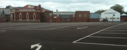
This is the site of the sugarhouse of Thornton, Watson & Co, Lime Street, Hull, that refined sugar for just over 100 years from the 1730s, and is now bounded on three sides by Lime St, Witham and New Cleveland St. The main building partially collapsed in 1868 and the site has had various uses since.
It's not known just how much evidence of the original sugarhouse remains, if any. The whole site has recently been made into a car park, however planning permission was granted before it became a statutory requirement for some form of archaeological study to be considered.
The line of Lime St changed after the collapse of the sugarhouse. I think that originally the SW corner of the main building would have touched what is now the west side of Lime St, where I'm told evidence of a substantial wall was found beneath the pavement during recent services work. Also a small portion of 'thin-brick' wall stood on the east side of Lime St, possibly the remains of the clerk's office close to the dwelling house. That has now gone, along with everything else above ground, though I feel the foundations have been left mostly undisturbed.
A pristine tarmac car park now covers the site and during its construction a deep trench was dug, into which drainage pipes were placed. The line of this drain, a rectangle roughly 10m inside the site's boundary, can be noted from the surface covers. I've been told, and seen in part, that walls were cut through and a particularly complicated brick drain was found, though its position probably makes it part of the soap factory immediately north of the sugarhouse. The western leg of the trench cut through the footprint of the refinery building.

Hull page


*****

LANCASTER - Phoenix St

Data ...
        Location : Lancaster - Site of Sugarhouse, Phoenix St, off St Leonardsgate.
        Grid :
        Sugarhouse : No
        Pottery : Yes
        Year of dig : 1929
        Sources : 'Sugar for the House' by Mona Duggan, Fonthill Media, 2013.

Summary ...
              "... archaeologists investigated the sugarhouse site in Phoenix St off St Leonardsgate. They found several pieces of red terracotta pottery sugar moulds, which are now in the Maritime Museum at St George's Quay. ... excavations at the site of Mitchell's brewery also produced sugar moulds."


*****

LIVERPOOL - Manchester Dock

© Bryan Mawer, 2012,
with permission of National Museums Liverpool.

Data ...
        Location : Liverpool - Site of the Manchester Dock 1780-1936 and the new Museum of Liverpool 2011-
        Grid : SJ 33923 90025
        Sugarhouse : No
        Pottery : Yes
        Year of dig : 2007
        Sources : National Museums Liverpool Blog
                      Museum of Liverpool - visit 2012

Summary ...
              The Manchester Dock was constructed in the 1780s, with sheds and cranes, an adjacent dock and its own entrance lock all added in the next three decades. The disused dock was filled in using sandstone rubble from the building of the first Mersey road tunnel in the 1930s.
During the excavations in 2007 sugar pottery was found in the infill behind the dock walls. The dig is briefly recorded on the NML Blog from which come these two quotes from the archaeologists ...
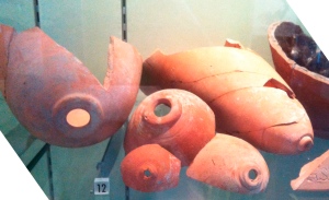
2 March 2007 - "One interesting find has been a dump of broken sugar moulds. These provide a direct link to two of the major industries of Liverpool: pottery manufacture and sugar refining. These pottery vessels, made in a smooth red earthenware, were probably made in Liverpool by one of the numerous potteries in the town. In shape they are a rounded cone with a small hole at the narrow end. They were used to refine sugar imported from the Caribbean and elsewhere. The mouth of the sugar cone was set over a pottery jar to collect the molasses that slowly drained out of the sugar during refining. We have a good idea of their date as they were dumped in the land-fill which was deposited to reclaim this part of the Mersey in the period 1796-1801." Rob Philpott.
4 April 2007 - "So far we have found more sugar moulds similar to those found earlier in the excavation, including one which although broken may be complete, and another with a complete makers stamp for W. Ashcroft of Prescot." Mark Adams.
This is the only piece of stamped/named sugar mould or jar that I know of to date. Flagons, yes, but not moulds or jars.

Moulds page


*****

LIVERPOOL - South Castle Street

Data ...
        Location : Two sites on South Castle Street, Liverpool
        Grid :
        Sugarhouse : No
        Pottery : Yes
        Year of dig : 1976 & 1977
        Sources : Journal of the Merseyside Archaeological Society Vol.4 (Innes & Philpott)
                      Journal of the Merseyside Archaeological Society Vol.5 (Brooks) [?? not found yet]
                      Archaeology North West Vol.8, Ch.6 (McNeil & Newman)

Summary ...
              The two areas excavated, in successive years, were at either end of South Castle St, just to the south of the site of the medieval castle. The 1976 dig was at the northern end of the street; the 1977 dig at the southern end, on the western side, over a section of the Pool.
From the limited info so far it would appear that both sites produced pottery that could be likened to sugar moulds (321-327, 329) and collecting jars (313, 318), but were not identified as such at the time. "313 - The fabric is red and the vessel shows signs of use, the slip having worn away from the inside of the rim." Whilst the summaries place such sherds in general fill and dumping at both sites, the report only lists context by phase and not pottery by context ... such detail in archives, I assume.
The reference in Archaeology NW that pointed me to JMA Vol.4 was clearly based upon the later findings reported in JMA Vol.5 (Cathy Brooks, following her work at York) as there's no mention of sugar in JMA Vol.4.
All the pottery finds were dated to before 1730 and may therefore be linked to the two earliest of Liverpool's sugarhouses (1670s) in Redcross Street/Preeson's Row area close to the Pool. We also know (from example at Manchester Dock) that sugar pottery was produced in Prescot, but as yet not sure of date (again Vol.5 needed).


*****

LONDON - Deptford

Data ...
        Location : Site of Deptford Power Stations, demolished 1992.
        Grid : TQ 3760 7780
        Sugarhouse : No
        Pottery : Yes
        Year of dig : 1997
        Sources : Post-Medieval Archaeology, Vol 38/1. "Excavations at Deptford on the site of the East India Company ... , London" by David Divers, Chris Jarrett ...

Summary ...
              The odd few references crop up for refining in Deptford, either side of 1800, even though at the time the markets for raw sugar and the finished products were way up river.
What is significant about Deptford is its pottery. We know from the directories that there were two sugar mould potteries, one in Copperas Lane, the other in Tanner's Hill, at a similar time to the sugarhouses, however there is archaeological evidence of mould making considerably earlier. Potteries in Greenwich produced earthenware vessels in the 16thC, and similar were established in Deptford in the 17thC.
In the autumn of 1997 an archaeological excavation was conducted by Pre-Construct Archaeology on the site of the former Deptford power stations, previously built on the land bounded by the Thames to the north, the Depford Creek to the east and Creek Rd to the south. The important early occupants of parts of the site were the dockyard founded by the East India Company, and the Trinity House almshouses.
The excavation report by David Divers was published in 2004 and the final paragraph of the initial summary reads ...
"The manufacture of pottery is another known activity on the site during the 18th century. No structural remains of any pottery were found, although a large quantity of pottery wasters and kiln waste was retrieved from land reclamation dumps."
Within the report, the detail, by Chris Jarrett, describes a series of pottery production waste dumps, containing late 17thC and 18thC wasters, found within the dock structure. These dumps had either served to consolidate the foreshore or assist in the construction of a new revetment. The reclaimed dockyard was completed before 1789, and it is thought the wasters were collected elsewhere and later moved in sufficient quantities when needed at the waterfront as the kiln waste was at least 50 years old before it was used as construction material.
Dating the sugar moulds found at Deptford was mainly based upon whether or not they were slip-coated, a process introduced in the late 17thC. Information from other sites would indicate the moulds dated from after c1680 but not later than c1789, maybe even the 1740s if they had been stored before use. As would be expected, a variety of sugar moulds and collecting jars were found, though as obviously none were complete the heights of the moulds could not be determined, only the rim diameters. They were Deptford redware and the majority of the moulds were white slip-coated internally.
The River Thames would have been an ideal means of transporting the finished moulds and pots to the London sugarhouses.


*****

LONDON - London Hospital Medical College

Data ...
        Location : London Hospital Medical College, Newark Bldg, New Road, Tower Hamlets.
        Grid : TQ 3456 8153
        Sugarhouse : No
        Pottery : Yes
        Year of dig : 1994
        Source : Post-Medieval Archaeology, Vol 29 p131. Annual summary 1994, Ponsford & Jackson.

Summary ...
              "What is almost certainly the Civil War ditch was found to be 5.5m wide and 1.4m deep. It was filled with waterlain silts, the earliest dating to the 17th century, and backfilled in the late 18th century. ... A large amount of post-medieval redware, sugar cone moulds and collecting jars was recovered from the infill of the ditch and later levelling of the site."
Another case of old or unwanted sugar pottery being put to good use.


*****

LONDON - Morocco Street, Southwark

Data ...
        Location : 5 Morocco Street, Southwark.
        Grid : TQ 3320 7965
        Sugarhouse : No
        Pottery : Yes
        Year of dig : 2005
        Source : London Archaeologist Volume 11 Supplement 2 p46.

Summary ...
              "Made-ground, dating to the 18th c, was found to contain a large quantity of fragments of 18th-c syrup jars and sugarloaf moulds which could indicate the presence of a small industrial or craft workshop. Above were located the remains of footings of a 19th-c building, probably part of the redevelopment of the site in the 19th c with light industrial buildings or warehouses. On the S side a post- medieval wood-lined lime pit was truncated to the N by wall footings. Natural strata were not reached."
As yet, no sugarhouse found on or near Morocco St for this date or any date.


*****

LONDON - Mortlake

Data ...
        Location : 61-69 and 71-75 High Street, Mortlake.
        Grid : 52077 17599
        Sugarhouse : Yes
        Pottery : Yes
        Year of dig : 1996-7
        Sources : MoLAS Archaeology Studies Series 9 - Early modern industry and settlement - Richmond & Mortlake, by Sloane, Hoad, Cloake, Pearce and Stephenson. 2003.

Summary ...
              Situated between the River Thames to the north and Mortlake High Street to the south, the sugarhouse, yard and adjacent tapestry works appear to have replaced a Tudor dwelling house with garden and pond.
The sugarhouse was established at 61-69 High Street in the 17th century, though the precise date is not known. Documents show that in 1688 a Quaker by the name of Mucklow and his partners ran the sugarhouse, by 1729 John Bentley was in charge, and in 1741 Thomas Emerson, William Chapman and Thomas Fuller had insured the property, though the policy was voided in 1743 when the business appears to have closed.
Built upon a series of arched foundations composed of a mixture of ceramic tile, brick and sandstone, the rectangular building measured 3.75m x 4m. However, further walls were found to extend to the east and west suggesting rooms existed either side of the main building, giving a total structure of 8m x 5m aligned parallel to the river. The 1741 insurance policy indicates that the structure to the west was 'warehouses', and to the east a 'dwelling house adjoining". None of the walls survived to more than 4 courses, and no internal floors survived.
A brick-lined drain ran from the sugarhouse across an external yard, of about 10m x 15m, directly into the river.
"The artifacts relating to the sugar house consisted of sugar cone mould fragments. Although none could be directly associated with the sugar house (they had been redeposited by later activity and recovered from period 4), they do indicate that the storage of sugar could have taken place on the site." - Stewart Hoad. [Just what the phrase "storage of sugar" means here I'm not sure. 'Sugar cone moulds' were used to produce sugar loaves, not store them. Once made, selling them would have been a priority.]
By 1745, the sugarhouse had been demolished and on the land represented by 61-75 High Street was built the first of two adjacent pothouses.


*****

LONDON - Old Paradise Street, Lambeth

Data ...
        Location : 11-21 Old Paradise St, Lambeth.
        Grid : TQ 30715 78910
        Sugarhouse : No
        Pottery : Yes
        Year of dig : 2005
        Sources : An Archaeological Evaluation, Compass Archaeology, 2006 (.pdf online).
                      London Archaeologist Volume 11 Supplement 2 p42.
                      Norfolk House Pottery (Biographical details), British Museum.

Summary ...
              The dig was on the north side of Old Paradise St and related to former terraced houses that were to the south of a large plot extending north to Church St. On Church St itself once stood the Norfolk House Pottery (1680-1799) and a sugarhouse run by William Watson around 1700 (Compass) and Thomas Jemmitt 1756-60 (Sun Fire Office). Jemmitt died 1762.
"The evaluation produced small assemblages of domestic pottery, the largest groups coming from a later 18th century well and a 19th century pit. There were also a few sherds probably deriving from the nearby sugar refining works, which operated in the same period as the Norfolk House pottery." ... "The pot also included a number of sherds of redware sugar moulds and collecting jars: these probably derive from the sugar refinery that operated on part of the Norfolk House site during the 18th century, although this was derelict by 1784." ... "An interesting element of the assemblage is the presence of sugar refining equipment (12 or 13 sherds, 10-11 ENV). Sherds of sugar mould were present in [11] and [28], while fragments of collecting jar were found in the same contexts and also in [9]." ... "... it has been suggested that, as the fabric of these wares differed from others in London, they may have been locally made (Webber)." - Compass.


*****

LONDON - Patience Street, Bishopsgate Goods Yard

Data ...
        Location : Patience Street, Bishopsgate Goods Yard (now Shoreditch High Street Station).
        Grid : TQ 3356083420-3374082240
        Sugarhouse : No
        Pottery : Yes
        Year of dig : 2005
        Sources : MOLAS BGX05 (online).
                      Correspondence with Jacqui Pearce of MOLAS, 2009-11.
                      Subterranea Britannica online (Nick Catford).
                      "Tracks Through Time: Archaeology and History from the East London Line Project", by Aaron Birchenough +, 2009.

Summary ...
              Bishopsgate Station opened in 1840 amongst the terraces and artisans' houses at the boundary of Shoreditch and Bethnal Green. By 1875 it was surplus to requirements as a passenger service and the site was extended to accomodate a huge three-level goods yard opened in 1881. In 1964 this was destroyed by fire, and some of its substantial remains were demolished in 2004. Excavations were undertaken in 2005 prior to, and in preperation for, the construction of the new Shoreditch High Street Station.
The dig uncovered large numbers of sherds of sugarloaf moulds and collecting jars ... so much, in fact, that it could not all be collected, and the sheer quantity of sugar refining pottery on the site meant that a sampling policy had to be adopted. Samples were collected from both the deposits spread across the site and from various trenches. There was one concentration of sugar refining ceramics associated with what was termed Building 7 on the site, which equated with 6 Patience Street (built around 1750). This property and the yard area yielded a large number of sherds from sugarloaf moulds and some collecting jars, but not the highest concentration on the site, which was associated with general levelling dumps in Trenches 11 and 13, to the east.
The sampled sugar refining ceramics dated from the 17th to 19th centuries, although the highest quantity of material came from 17th-century contexts.

"The crowded living conditions were exacerbated by various trades and small-scale industry undertaken within the same buildings. ... Evidence for other small-scale industries included ... fragments of moulds and syrup collecting jars for processing sugar imported from the plantations in the West Indies." (Birchenough), which rather plays down the quantity of sherds present.

I've found no recorded evidence for a sugarhouse existing in this immediate vicinity. The ceramics cover a long period from the 17th to 19th centuries, but even though they cover the London refining years, that's a long time for any sugarhouse or sugarhouses to be running on one site and not be noticed. Identifying sites before 1700 is very difficult, but, in general, refining did not move out of the City in any big way until around 1750, no new sugarhouses were built there after about 1810 and the last closed in 1853. The first sugarhouse east of the City was in Angel Alley (half a mile south of this site) in 1719 and the alley was still refining in 1830.
If these excavations had been in, say, Upper Thames Street, we could no doubt identify the sugarhouse fairly easily, even though we'd hit problems before 1700, but at least we would know we were dealing with a known refining street .... in this case, there is no evidence of refining there. Horwood, in his mapping of London in the years either side of 1800, cross-hatched properties insured by Phoenix Fire Office, many of them sugarhouses. He did indicate one such building in Patience Street (probably numbered '2') but it was just one in a row of terraced houses. As a sugarhouse it would have been too small (especially to have utilised all the moulds and pots found), would have been the farthest from the river identified so far, and would not have appeared in any of the trade directories of the period. The houses in Patience Street were still there in 1851, but had been demolished by 1861. The occupations of the residents in the 1841 & 1851 censuses show nobody involved in sugar, and I think it probable that Horwood's cross-hatched house (second from Wheeler St) was that of a chair maker and woodturner, with folks in the same street being weavers and carpenters. A scum boiler would have been better suited to a small premises in Patience Street but would have been a good distance from operating sugarhouses, essential for his raw material, and would not have accumulated such a large stock of moulds.
If there had been a pottery on the site then it would surely have been kiln wasters, rather than finished vessels, that would have been found, but they were not in evidence.
So, the houses in Patience Street were not touched by the building of the original station, but were demolished before 1861 and built over before, or during, the expansion in the 1870s. These houses may have had cellars and yards that needed back-filling prior to levelling and building.
By 1860, the East End sugar refining industry was in decline and by 1881 there were less than a handful of sugarhouses left. Most owners tried to sell their businesses/premises as going concerns, but under the prevailing market conditions usually found it impossible. Sugarhouses were sold as warehousing or simply demolished. But what of the contents? The astonishing thing about sugarhouses was the huge quantity of moulds used, and each mould needed a collecting jar. When the sales were advertised (eg, The Times) the numbers of moulds were often mentioned, sometimes well into 10s of thousands at a single sugarhouse, eg: 1837, Leman St, 30,000 pots and moulds; 1840, Rupert St, 10,000 pots and moulds; 1853, Stratford, 2000 earthen pots; etc. Also during this time, those sugarhouses still successful were changing to the use of centrifugal machines rather than moulds and jars and so were disposing of their many thousands of vessels. These were no use to anyone, so off they went for hardcore in revetments, under buildings, railways and roads, or just spread as hard-standing. Some of these sugarhouses had been working, maybe under different ownership, for upwards of 100 years and they would have been using moulds both old and new. This could account for the spread of dates and the spread of finds on the site ... levelling layers would have filled cellars, etc, with large quantities of the same material.


*****

LONDON - Prescot Street

Data ...
        Location : Prescot Street, Whitechapel
        Grid : ~TQ3390180927
        Sugarhouse : No
        Pottery : Yes
        Year of dig : 2008
        Sources : Prescot Dig online

Summary ...
              "Sugar refining is indicated by fragments of 111 collecting jars and 10 sugar moulds, ..." "Sugar refining appears to have been an important industry along the riverside and fragments of sugar mould and collecting jar are present on most sites in the area, but very few were found on the present site."
This street was surrounded by sugar refining, but little of note for itself. The Lilkendey family used premises in Prescot St, 1788-1835, though their main sugarhouse was in Wellclose Sq, and it may have been the same premises (No.3) used by Henry Henrickson in 1846.


*****

LONDON - St Mary Axe

Data ...
        Location : Baltic Mercantile and Shipping Exchange, St Mary Axe, City
        Grid : TQ33318125
        Sugarhouse : No
        Pottery : Yes
        Year of dig : 1995
        Sources : LAARC Online Catalogue - Site record MAE95

Summary ...
              The site of the late Baltic Exchange, now that of The Gherkin. Roman evidence and many early pits, through to Victorian foundations and later, though little in between.
"A large pit in the E of the site contained much post-medieval sugar loaf mould, indicating a mould manufactory nearby." ... evidence of such a pottery would be a great find, however we should also consider other possibilities as the source(s) of the moulds. There was sugar refining a few yards away in Lime St 1729-1817, and 1698 in Cornhill, and almost continuous refining in Gravel Lane Houndsditch 1728-1839, and the possibility of the very earliest refiners in Mincing Lane; this location is on the northern edge of area of the City occupied by the sugar brokers, merchants and coopers ... two such examples - Thomas Wilson, a London MP and merchant of 4 Jeffery's Square, St Mary Axe (smack in the middle of this site) promoted Bills in Parliament in 1822 and 1823 defending the sugar refiners and the West Indian colonies; and of course the notorious James Lodge, sugar broker of Little St Helens, whose case Lodge v Fendall made it into case history in 1778.


*****

LONDON - Swan Street, Southwark

Data ...
        Location : Former Sorting Office, Swan St, Southwark
        Grid : TQ32457965
        Sugarhouse : No
        Pottery : Yes
        Year of dig : 1998
        Sources : LAARC Online Catalogue - Site record SWN98

Summary ...
              "Three pits contained large quantities of white slipped sugar moulds dating to 1650-1750." White slipped moulds probably dated to the second half of this period. No sugarhouses found close to this site ... yet.


*****

LONDON - Upper Thames Street

Data ...
        Location : 78 Upper Thames Street - immediately east of junction with Queen St Pl
        Grid : TQ3245580750
        Sugarhouse : No
        Pottery : Yes
        Years of dig : 1988-9
        Sources : LAARC Online Catalogue - Site record TEX88

Summary ...
              Extensive and complex dig, back to the earliest Roman development of the Thames waterfront at this site.
"A post-medieval waterlogged pit contained several wooden bowls, two brooms, packing boxes, a pannier and a child's ball and skittle, together with Spanish, German and English domestic pottery. There were also some industrial ceramics used in sugar refining."
The waterfront was known as Three Cranes Wharf until its demolition to make way for Southwark Bridge in 1819, and Queen St connected it to Upper Thames St. This tiny area - of the wharf, the short stretch of Queen St and the adjacent properties in Upper Thames St - was refining sugar for the century prior to the building of the bridge.
The Thames Exchange building (72 Upper Thames St) now standing on the site covers the whole area between the river and Upper Thames St, and Queen St Place eastward to just beyond the old 78 Upper Thames St. It's unlikely that the sugar pottery was definitely from No.78 ... research to date shows there were sugarhouses at Three Cranes from 1725-40, at 49 Queen St 1764-1800, at 57 Queen St 1794-7, and at 78 Up Thames St 1768-1811, with all of these properties now "under" that one building.


*****

LONDON - Whitechapel Road

Data ...
        Location : Royal London Hospital, Whitechapel Road
        Grid : TQ34558171
        Sugarhouse : No
        Pottery : Yes
        Year of dig : 2006
        Sources : LAARC Online Catalogue - Site record RLP05

Summary ...
              On the south side of Whitechapel Road, close to its junction with New Road (and opposite my 3xgt grandfather's grocery shop) ... "In the northern half of the area, burials of an earlyÐmid 19th-c cemetery associated with the hospital cut through these deposits. There were 265 burials, including 66 showing evidence of autopsies and 89 Ôcoffin loadsÕ of dissected remains. The southern boundary of the cemetery was defined by a brick wall. Outside the boundary a substantial dump, mostly of pottery sherds and wasters from sugar refining vessels such as sugar moulds, was recorded."


*****

LONDON - Woolwich

Data ...
        Location : Woolwich - immediately to east of Old Ferry Approach (now Waterfront Leisure Centre).
        Grid : TQ 433793
        Sugarhouse : No
        Pottery : Yes
        Year of dig : 1974
        Sources : Post-Medieval Archaeology, vol 12, 1978, pp30-85, "A 17th-century Kiln Site at Woolwich" by Sylvia Pryor & Kevin Blockley.
                      Post-Medieval Archaeology, vol 17, 1983, pp1-14, "Aspects of the sugar-refining industry from the 16th to the 19th century" by Catherine M Brooks.

Summary ...
              What began as a routine excavation revealed a kiln site of unique importance. Two kilns, both dating from the third quarter of the 17th century, with the evidence suggesting the one producing stoneware was earlier than that producing earthenware. At the time this was the only stoneware kiln of the period yet discovered in Britain. The classification of some 60,000 sherds of pottery suggested a third kiln, earthenware, was operating nearby around 1660. All production had ceased by about 1680.
The sugar moulds, and other industrial wares, were produced in one of the earthenware kilns almost certainly using a local clay.
"Sugar Cones ... This class represents 525 vessels, with rim diameters between 18 and 35cm. None of the vessels in this class are glazed and only twenty three show signs of a slip." - Kevin Blockley.
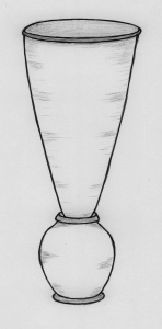
The single example of a mould shown in the report was a very slim conical shape 18cm diameter and 46cm high.
68 collecting jars were present, each with heavy rolled rim (11cm dia) and applied foot ring. All were internally glazed. These are listed as storage jars in the original report and Catherine Brooks points out their connection with sugar refining in her later paper.

Extra note ...
              Within the report's discussion regarding the stoneware kiln, mention is made of a Peter Wilbert, potter, who appears in Woolwich before 1643 and may have tried to produce stoneware there some years later. He was probably from a family of potters who settled in Lambeth in the 1570s and moved away around 1615, but who where found again in Greenwich 1629 and then Woolwich 1643. In my transcription of the Blois ledger at Ipswich, the sugarhouse, in 1618, was supplied with "forms [moulds] and pots" by Peter Wilbart potter of Stoke (Ipswich?) ... does this information fill those missing years, I wonder ? ............ Further research has not found evidence of a pottery or of the name Wilbart/Wilbert in the Stoke area of Ipswich. However, there was a pottery industry not far away at Stock in Essex, and this place name was also written as Stocke. No Wilbart/Wilbert there either, but wherever the family was for those few years it need not have left any records in the church registers or wills indexes.


*****

PLYMOUTH - Cockside

© PDAS.

Data ...
        Location : The Boatyard, Coxside, Sutton Harbour, Plymouth.
        Grid : SX 4854 5433
        Sugarhouse : Yes
        Pottery : Yes
        Year of dig : 2007
        Sources : Current Archaeological Position - Boatyard Project, 2007 (.pdf online)
                      Project Design for an Archaeological Excavation and Recording Project at the Boatyard Site, Sutton Harbour, Plymouth, Exeter Archaeology, 2007. (.pdf online)
                      PDAS Notice Board (online)

Summary ...
              The two .pdfs discuss the probability of the foundations of the 17th century stone-built being found in situ along with associated sugarhouse pottery.
As yet, after many enquiries, I've not been able to find a report of the completed dig. The brief notes to the PDAS by John Salvatore read ... "Recent excavations in Plymouth have centred upon Sutton Harbour, particularly the area to the east of Sutton Pool. In advance of construction for a major building at the Boat Yard site, Exeter Archaeology have uncovered the remains of buildings fronting the former quay wall. The area was reclaimed in the 17th century and this was followed by the erection of quays and warehouses.
The most significant building known from cartographic sources was the 17th century stone-built Sugar House which, as the name suggests, was involved in the processing of sugar refining using the raw materials imported into Plymouth primarily from the West Indies. Very well preserved remains of this building, which perhaps continued in use into later centuries, have been uncovered together with considerable evidence for the refining process including specialised ceramics such as syrup jars and cones used in the manufacture of sugar."

This was the sugarhouse of Samuel Buttall, followed by his son Humphrey ... from the 1660s through to the 1720s.

Plymouth page


*****

SOUTHAMPTON - Gloucester Sq

Data ...
        Location : To east of High St, just north of Gloucester Square. (Beneath SE corner of Friary House, Briton St.)
        Grid : SU 4209 1107
        Sugarhouse : Yes
        Pottery : Yes
        Years of dig : 1960 and 1985-6
        Sources : www.heritagegateway.org.uk/Gateway/Results_Single.aspx?uid=MSH1368&resourceID=1016 (Southampton HER).
                      "Sugar Refining in Southampton - Two Sorts of 18th Century Industrial Ceramics" by J.C. Drake, 1987 (Museums Diploma Project).
                      www.mawer.clara.net/sales.html (Advertisement for sale of premises, Southampton St James Chronicle 1775).

Summary ...
              John Brissault built the Sugar House in the early 1740s on the site of the old Friary, close to the High St leading to the Town Quay and with a useful supply of freshwater. By 1774 he was bankrupt and the refinery was soon in use as a granary. The building, still retaining its original name, remained in industrial use through to WWII.
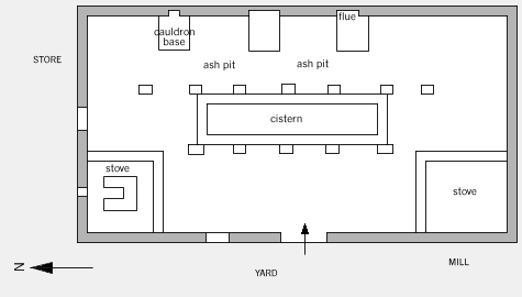
A substantially built sugarhouse of 90ft x 45ft, with walls 2ft 6ins thick, massive stone foundations, and water cistern centrally beneath, was excavated. Three flues and pan bases were identified along the long east wall, with ash pits between them. Stoves were found in the two western corners of the building. The original 1775 sale information, along with 20th century photographs, show the sugarhouse was to have been of 7 storeys and with it a dwelling house adjoining, a mill house, spacious lodging rooms for workmen, and all necessary store houses, cooperage, stabling, coal house and yard.

Fragments of pottery were few. The 15,000 pots and moulds for sale at closure were either purchased for use, dumped elsewhere as hardcore, or possibly transferred to the Brissault refinery in London. There were "152 fragments of conical vessels, 10 fragments of thick-based pots, all made in a red fabric, derived from 3 adjacent excavations" (Drake) - the sugarhouse itself, sealed into the yard surface and along the access lane running west from the yard.
To quote from Drake's excellent descriptions ...
"Thick-based pots: all the fragments were of similar vessels, though in two sizes, with thickened, heavy bases, their height about 2½ times the base diameter, and with shallow, thick and simple necks, of approximately the same diameter as the base. The bases showed traces of excessive knife trimming externally, and all the vessels were heavily rilled internally. The outer surfaces had been wet-wiped."
"Conical vessels: two types were identified: Form A: approximately 220mm diameter at the broad end, 380mm high, with narrow end pierced before firing by a hole about 8mm diameter surrounded by an external collar 4mm thick and about 20mm diameter. The rim at the broad end was slightly thickened, and had a flat surface perpendicular to the longitudinal axis of the cone. ... The rims appear to have been knife trimmed, though without facets and the outer and inner surfaces of the cone smoothed at the leather-hard stage to a very fine finish. Form B: approximately 420mm diameter at the broad end, 650mm high, with narrow end pierced before firing by a hole about 18-25mm diameter surrounded by an external collar 6mm thick and about 65mm diameter. The rim at the broad end displayed considerable thickening on the outside of the vessel, and was a simple rounded form in section. Many showed facets from knife trimming at the rim, and all exteriors had been wiped when the clay was still quite moist, probably with a pad since no finger marks were visible externally. The interiors of some showed traces of shallow rilling. ..."
"Finish: None of the thick-based pots displayed any applied finish, ... .105 of the 152 sherds of conical vessels displayed a thin, streaky white slip, wiped on to the interior. On the rim sherds this slip continued up to the top of the internal wall, but there were 4 sherds showing a clear division between slipped and unslipped zones, suggesting that some examples were slipped only part way, with the broad end of the cone unslipped. The slip was in general considerably worn."

Southampton page


*****

YORK - Skeldergate

Data ...
        Location : City Mills, Skeldergate, immediately north of the Bonding Warehouse.
        Grid : SE60315135
        Sugarhouse : Yes
        Pottery : Yes
        Years of digs : 1972 and 1983
        Sources : YAT Interim 8/4, 1982 - Cathy Brooks.
                      YAT Interim 9/3, 1983 - Colin Briden.
                      Post-Medieval Archaeology, vol 17, 1983, pp1-14, "Aspects of the sugar-refining industry from the 16th to the 19th century" by Catherine M Brooks.
                      YAT archives for both digs.

Summary ...
              A trial trench on this site in 1972 provided two vessel forms from post-medieval levels that were later recognised as being sugar moulds and syrup jars associated with a sugarhouse.
"There were about 132 moulds, represented by 432 sherds ... they were in a red earthenware and unglazed ... a number have a smooth white-slipped finish to the interior, and many of the unslipped vessels also have trimmed and smoothed interior surfaces." The moulds varied in size from 17 to 44 cm rim diameter.
The collecting jars "which have heavy rolled rims and ring-foot bases" were in just two sizes. All were in red earthenware and internally glazed. "At the rim the glaze is often worn away on the interior, presumably by the sugar-loaf mould." "There were 268 sherds of this vessel form, representing about 65 jars. The group dates to the late 17th of early 18th century."
Several clay-lined cisterns were also found.
"There are wasters amongst the jar sherds, probably indicating very local production."

In 1983, on the same site immediately north of the Bonding Warehouse, "... two trenches were laid down through areas straddling the Trust's 1972 excavation."
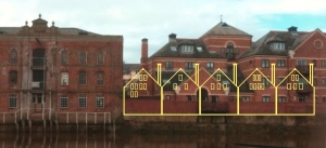
The outline of the sugarhouse was clear, though many of the details had been destroyed by the later building of the Dutch-gabled wine vaults. Areas of burning (a sugarhouse required a number of hearths and stoves) and rooms containing lime and white clay, were recorded, as well as the fact that the rear wall of the sugarhouse stood on top of the 14th century river wall. Beam slots cut into the floors confirmed that the wine vaults (1720s-1960s) were built later than the sugarhouse.
The dimensions of the sugarhouse are uncertain ... the two areas into which the trenches went were each 5m wide and about 25m long, with dividing walls, but dwelling space was also mentioned in the deeds. Double this area may have been used.

[Research shows that John Taylor ran the Skeldergate sugarhouse from 1680 to his death in 1709, and it was sold for the building of the Dutch-gabled wine vaults in 1719.]

York page


*****

MONTSERRAT, WI - Galways

Data ...
        Location : Galways Sugar Plantation, Montserrat, WI.
        Grid :
        Boiling House : Yes
        Pottery : No
        Year of dig : 1981
        Source : Post-Medieval Archaeology, Vol 16 pp21-27. A sugar-boiling house at Galways: An Irish sugar plantation in Montserrat, WI, by Lydia Mihelic Pulsipher and Conrad M Goodwin.

Summary ...
              From a short, but clear, report, with plan and excellent photographs, we actually see a boiling house so often only represented in sketch form.

"During the 1981 season effort was concentrated on a 1.5 acre portion of the central complex occupied by the boiling house, cisterns, cattlemill and windmill. ... the boiling house was the first structure to be examined: it is the physical centre piece of the complex; it is a particularly imposing and beautifully constructed building which has long been admired ... .
The boiling house, which is built across the slope, is a two-storey structure set into the hillside so that the upper floor is at ground level on the upslope side. The long east and west walls run for 72.8ft, and each has nine arched window openings on the exterior upper level. Only six of the windows on each side are actually open to the interior. The second, third and fifth arches are closed with a recessed cut stone face. Careful examination of the interior walls has led us to conclude that these windows were never open. Apparently the arches were included on the exterior face purely for aesthetic purposes.
The north and south gable ends of the boiling house are 27ft wide. Both had round gable windows (4ft in diameter) that were originally louvred to control ventilation. Although the south gable has collapsed into the building, the north gable is intact and rises 22ft from the door sill on the upper level to the peak. Below the round window is an arched doorway flanked by two arched windows. The south wall contains only a large rectangular doorway slightly off centre to the east. The boiling house upper level is divided into two rooms. The north room had a wood floor which disappeared. The use of the room has not been determined. The south room, roughly twice the size of the north room, has a cobbled floor and originally five iron kettles mortared into the floor along the west wall over the boiler and flue system. ...
The lower level of the boiling house contains a room at the north end measuring 23ft by 27ft. It was once partitioned by a stone wall running the length of the room. It also has a cobbled floor and the walls were at one time plastered. This room has a straight-arched doorway flanked by two straight-arched windows opening to the west. The southern two third of the lower level are occupied by the boiler and flue system which heated the boiling kettles. ...
In the process of removing debris from the inside and outside of the boiling house, large quantities of red clay fragments were uncovered. Their curved shape and size suggested roofing tiles. ... "


*********


HOME/DATABASE
LOCATIONS
SITE MAP